
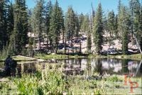
Most (90%) of Yosemite is managed as Wilderness (essentially everything more than 1 mile from a road). The word wilderness is best defined by what the law says, not by anything else. From the Wilderness Act 1964 PL 88-577 -- Areas where the earth and its community of life are untrammeled by man, where man himself is a visitor who does not remain. And areas managed to secure for the American people ... and future generations the benefits of an enduring resource of wilderness ... unimpaired for future use and enjoyment. This results in basic rules such as a size of at least 5,000 acres, no construction, no vehicles, no powered machines (a lever is a machine, so hand saws, but not power saws). It is also where you see fewer people. We have spent several consecutive days on trails, and encountered less than 5 people. You have to walk to see it. Horses are allowed on most of the trails -- like everything this is both good and bad (it means trails need to be well constructed, but also that trails can be worn and dusty).
To visit the wilderness, you need to know the rules, which change from year to year (so look at the Yosemite National Park Backpacking Information Pages). Of course, if you enter on foot on a trail, you need to also follow the rules from some bordering National Forest. The primary rule is the wilderness permit which serves 2 purposes, first to make sure you get the current information on rules and conditions, and second to spread people out (both in time and space).
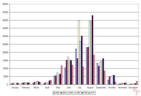 Backcountry (wildneress) overnight stays vary by the month,
and are heavily influenced by the snow levels. Statistics (taken from the
Park Service site) show variations by year. Note that January 1997 was
the year of the flood -- heavy rain on top of early snow melted the snow
and flooded the backcountry streams, and the valley. Several bridges were
washed out -- like all natural events, traces remain but now have become part
of the landscape.
Backcountry (wildneress) overnight stays vary by the month,
and are heavily influenced by the snow levels. Statistics (taken from the
Park Service site) show variations by year. Note that January 1997 was
the year of the flood -- heavy rain on top of early snow melted the snow
and flooded the backcountry streams, and the valley. Several bridges were
washed out -- like all natural events, traces remain but now have become part
of the landscape. |
||
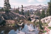
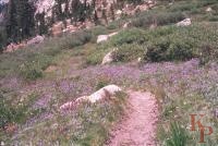 Matterhorn Canyon. This is the only place where I have encountered
lupine so thick over such a large area that you can smell the aroma.
Lupine are not famous for their aroma, mostly because it is weak.
Matterhorn Canyon. This is the only place where I have encountered
lupine so thick over such a large area that you can smell the aroma.
Lupine are not famous for their aroma, mostly because it is weak. |
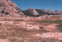
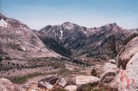 From Burro Pass you get a good view of Matterhorn Canyon.
I have seen the real Matterhorn, and the one in Yosemite is not
even close, hence no picture of it.
From Burro Pass you get a good view of Matterhorn Canyon.
I have seen the real Matterhorn, and the one in Yosemite is not
even close, hence no picture of it. |
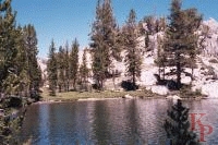
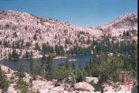 Smedberg Lake isn't close to any trailheads so it
gets PCT traffic and those on long loops.
Smedberg Lake isn't close to any trailheads so it
gets PCT traffic and those on long loops. |
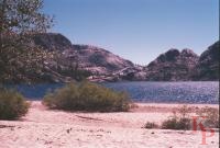 Also in the region north of Tioga Road, you find Benson Lake.
Some call this the Benson Riveria (a short detour off the trail for
the PCT thru-hikers). The camping is on the broad
sandy beach. It has all the advantages of a beach, and all the disadvantages.
Also in the region north of Tioga Road, you find Benson Lake.
Some call this the Benson Riveria (a short detour off the trail for
the PCT thru-hikers). The camping is on the broad
sandy beach. It has all the advantages of a beach, and all the disadvantages. |
 Kerrick Canyon has very little traffic. It is not a secret, it is just
a long hike from any direction.
Kerrick Canyon has very little traffic. It is not a secret, it is just
a long hike from any direction. |
 Arndt Lake is a short detour, but like all lakes there is always somewhere
to camp (as always at least 100' from water).
Arndt Lake is a short detour, but like all lakes there is always somewhere
to camp (as always at least 100' from water). |
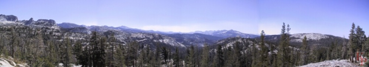 When you reach the top of almost any ridge you are
rewarded by outstanding views. Such as this from near Sunrise High
Sierra Camp
When you reach the top of almost any ridge you are
rewarded by outstanding views. Such as this from near Sunrise High
Sierra Camp |
||
 High ponds throughout the Sierra
are slowly becoming meadows as at Ten Cloud.
High ponds throughout the Sierra
are slowly becoming meadows as at Ten Cloud. |
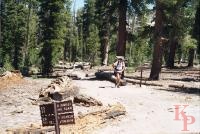 The metal signs with cut out letters are still common on backcountry
trails.
The metal signs with cut out letters are still common on backcountry
trails. |
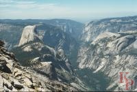 Yes, Half Dome is backwards. You get this view from Clouds Rest.
You can also see Cathedral Rocks and El Capitan in the
background. Much more interesting than the view from the other
side. And you look down on Half Dome.
Yes, Half Dome is backwards. You get this view from Clouds Rest.
You can also see Cathedral Rocks and El Capitan in the
background. Much more interesting than the view from the other
side. And you look down on Half Dome. |
 Iseberg Pass provides access to the upper Merced Canyon.
Also you see almost no one. The access is from the forest to the south.
The trail down the Merced to Yosemite Valley is a much longer trip.
Iseberg Pass provides access to the upper Merced Canyon.
Also you see almost no one. The access is from the forest to the south.
The trail down the Merced to Yosemite Valley is a much longer trip. |
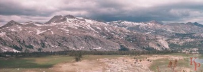
 The southern reaches of the park have many opportunities for hiking
without crowds.
The southern reaches of the park have many opportunities for hiking
without crowds.
|
|
 Return to my Yosemite home page.
