
Yosemite National Park encompasses some of the best scenery of the Sierra Nevada, and is the jewel of the National Park System. Yosemite provides a different experience for everyone who visits. For some, it provides a trip of a lifetime, for others, a lifetime of trips.
2022: The winter has started wet, but it is still only half of the normal snow for the year (so better than 2021, but still potentially a dry year).
2021: COVID continues to impact tourism and Yosemite. For the summer, the shuttle is not operating, some services are restricted, and day-use entries are limited with required reservations. The valley roads have a modified circulation pattern (for the high-traffic season) to deal with the increased traffic due to no shuttle. Partly beacuse of closures, Wawona Hotel is undergoing renovations so it remains closed (reopened for the usual Christmas season). While the initial plan was to close Glacier Point road for major rebuilding in 2021, it is now scheduled for 2022. Even more than 2020, the winter was dry, so don't expect much for the falls this summer. The Yosemite Lodge has installed 8 EV charging stations!
2020: This is a strange year. COVID closed the park for weeks. The current status is entry by reservation only (overnight reservation, or online day entry). Most indoor facilities are closed, and the shuttle is not operating. This includes the Mariposa grove shuttle. Also campgrounds are limited and the Wawona Hotel has remained closed. The backcountry is available for hiking! Snow was under the long term average and so water levels are very low already in July. And next year Glacier Point road is scheduled to close for rebuilding.
2018: Mariopsa Grove has reopened. The shuttle works well and there are almost no signs of the old parking lot. In the valley, the new traffic patterns are up and running. Some things work better, but there are always the crowds. Day parking is primarily near the visitor center (Shuttle Stop 1), with expanded parking near the Lodge (really Stop 7). Tour bus parking has moved to the former ice rink location (and those shuttle stops are removed -- at least in the off-season). Still only 2 charging stations (see 2021). 2018 had early floods (both from rain in winter and again with an early snow melt that included rain) that moved some of the sand in the river. Fall has been extremely dry.
2017: Spring-May: A lot of snow for the winter, but a somewhat early melt. High flows in the Merced for April and May. The winter storms cause problems for the roads, but all the western entrances are open on May 1. Work continues on the valley traffic flow and reworking of the day use parking, maybe it will be done for the summer crowds, though weekend crowds are large for the high water.
After a sometimes rough start the new concessionaire is about the same as the old for the visitor. Changes to traffic and parking in the valley are being made in the winter of 2016-2017.
The park concessionaire changed March 1, 2016. At the same time, some of the changes in what may be offered, as determined by the master, plan have been implemented.
2016: Mid-May, Tioga not yet open, but seems to be on schedule for Memorial Day weekend, or earlier. February. Snow is generally average, so far. Stream flows are a bit above the median, partly because it has generally been warmer. The fire area above CA-140 (the "all weather" highway) will be a continuing problem -- the road closed briefly in January, but later rain and snow did not close it.
2015: Spring. Water is running less than normal, but not at record lows mostly because it has been warm so whatever snow fell earlier is melting rapidly. Glacier Point road opened in late March, 2 weeks before the nominal time to even survey the road for plowing needs. Tioga Pass opens May 4, but there is construction on that road in 2015.
The 2018 floods moved some sand, but fall is always dry in Mirror Lake. Tenaya Creek in the Mirror Lake (changes through the year.) The area will be dry early in the season. Again, this (2015) is not a banner year for the falls. Summer may have more fires, especially in the neighboring forest, like in 2014 (after the large one in 2013). Many were caused by human actions. The forests are dry and trees are stressed with the bark beetle making in somewhat worse.
2014: Tioga Pass opened May 2. Not the earliest, opening, but close. And this was a week after about a foot of new snow. The issue for 2015 will likely be available services with an early opening.
Winter 2013-2014: After low 2011-2012 and 2012-2013 snow seasons, 2013-2014 is shaping up to be worse. The summer of 2014 is drier than 2013 (when stream flows approached the record lows from the previous modern drought periods). Snowpack was lower and the reserves from the most recent wet winter (2010-2011) are completely gone.
The area protected by the park designation (about 3081 km²) covers about 2½ times that of the city of Los Angeles (and thus is much smaller than Los Angeles County -- most counties in California being on the large side). The park has many different sections, some are overrun with visitors, others see few people each year. Yosemite presents a classic example of the tension between access and preservation that defines the purpose of the National Park System (conserve for enjoyment of current and future generations). If you do not preserve the parks, there is nothing to visit. If visitiation is too great, there is nothing left to preserve. If no one visits, it is forgotten and support for preservation does not exist. Through the history of the parks, there are examples of all of these happening. Indeed in the history of Yosemite all of these happened -- failure to preserve, overuse, and loss of scenic wonders because few people visited.
|
|
Yosemite is a lot like Shakespeare -- one cliche after another, one iconic view after another. Ansel Adams had a lot to do with that. This site is a personal view of Yosemite. There are a lot of official and touristy web sites for the park, look at them if you want official information. The site is never complete, there will always be changes and additions. Note that each heading is a link to more information and pictures. A similar size region of steep glacial walls and waterfalls is the Lauterbrunnen Valley in Switzerland.
Most of the park is not Yosemite Valley, yet most people who visit only see the valley. The length of the valley (which has all the people and traffic along with many iconic views) is about the same as the distance from Beverly Hills to the beach, and all of it is accessible from only one road (the one-way loop road, up one side of the river, down the other). So compared to traffic on Wilshire Blvd., Yosemite is not crowded. See the map from Google. To get a sense of scale, view other places at the same map scale. If you are not up to walking or biking to all the valley sights, use the shuttle (park the car in the lot or at your hotel outside the park and leave it there). In the summer, a second shuttle operates to the lower valley areas, but not to directly to Bridalveil Falls (an easy half mile walk) or the Tunnel view parking area (a longer, less used walk). You also need to get off and walk to Mirror Lake.
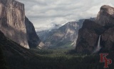
Tunnel View (Discovery View) is the spectacular entrance to Yosemite Valley for those arriving from Wawona and the south (Fresno via Oakhurst). The view changes through the year. This is sometimes referred to as Inspiration Point, but the real one is located on the old road (used before the tunnel), and is a steep hike up from the parking lot on the South Side of the road. Old Inspiration Point is more remote and is located on the valley rim above the parking lot (accessible from Glacier Point road or continuing up from Inspiration Point).
The view, while timeless, changes with the sun, changes with the weather, changes with the seasons, and changes from year to year. No matter when you visit it is unmatched. In the fog or a snow storm it might be a bit lacking, but other than that you must stop. The recent construction of the new viewing area extended the pedestrian zone (don't park in the bus-only zone, the bus drivers and their passengers won't be happy). There are usually people exactly where you want your picture, but anywhere along the east side is good. Parking is available on either side so you do not need to turn across traffic.
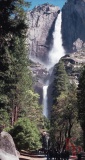
Yosemite is cliffs, falls, meadows, streams, trails, animals, flowers, and much more. Famous falls include Yosemite Falls, (changes through the year.) Nevada, Vernal, Illilouette, and Bridal Veil. In the Spring you also see Silver Strand, Horsetail, Ribbon, Sentinel, and others. The falls are a product of the geological and glacial forces that built the valley. Water level varies by season due to California's climate with winter rain (and snow) and summer sun.
The standard views of Yosemite Falls from the valley floor. Upper Yosemite Fall 1430 feet, Lower Yosemite Fall: 320 feet. (Middle is somewhat hidden.) A total drop of 2,425 feet (739 Meters).
In the summer, the most impressive view is from high above the valley floor at Glacier Point.
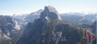
This is one of the few places in the world where you get the "Oh wow!" response from kids. Drive to it in the summer, ski to it in the winter. This is the most accessible view of the valley from the rim. The Glacier Point road is closed by snow all winter and most of the spring (and sometimes part of the summer). Facilities are closed in the fall to prepare for the winter snow closure. You can walk (4.8 miles (up) via the 4 mile trail), take the shuttle (not frequent) or drive (go early or wait to park).
Sentinel Dome is an easy hike from the road with clear views in all directions (and not crowded early). The Washburn Point turnout provides a slightly different viewing angle for Half Dome, the Merced River and Tenaya Creek drainages. Many visitors to the park never make it to Glacier Point. They miss one of the highlights, though their failure to visit makes it less crowded for the rest of us.
The road through Tuolumne provides the easiest access to a high Alpine meadow in the Sierra. From the east you have a long steep climb to the park boundary at Tioga Pass -- a relatively low pass over the Sierra, which is why the road was built there. Then the Tuolumne meadow area with the campground and visitor center. Tenaya Lake is a good place for starting an interesting hike to Clouds Rest (you can make it more interesting by continuing to the valley, if your car can drive itself). Olmstead Point provides a view of Half Dome and is a critical avalanche zone for the snow plows every spring. The road continues down into the forest past White Wolf (cabins available in the summer if you reserve early enough) and connects to the other park roads at Crane Flat (near the Tuolumne Grove).
Many trails start from the road, which can save you the long climb from the valley floor. Winter and spring access is possible only if you use skis or snow shoes, but summer and early fall are great times to visit and to get away from the crowds. In the fall, when facilities are closing, overnight parking restrictions make hiking difficult but reduce the crowds -- once it snows the road is closed and your car would be a hazard for the spring plowing.
Note: Mariposa Grove access will be limited for the next 2 years (2015-2016) as the roads are being removed and trails rebuilt. Work began in 2015 (access is always limited in the winter, if it snows). Some time in 2016 the new shuttle will begin operating. During this time access to the upper grove will be possible via a long hike.
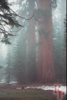
Wawona was used by US Army for the original management of Yosemite National Park. This original (1890) version of the National Park did not include the state managed areas of Yosemite Valley and Mariposa grove. Mariposa Grove even served as a campground for many years until the recognition of the damage that such activities cause to the trees. Today the grove is accessible by trails or via a tram (open truck, much like some of the valley tours) to the museum near the top. Take the trails and see the deer, and occasionally a bear.
Parking anywhere in Yosemite is limited (especially compared to places like Yellowstone, where even with the large parking lots, you may miss some geysers because of full lots). The Mariposa lot often reaches capacity so the shuttle from Wawona is strongly suggested (or even required) for access to Mariposa. If you come from the Valley you will arrive with everyone else and find the lot already full. If you come from Fresno you will arrive after the Valley crowds. So stop in Wawona and take the shuttle. You can walk from Wawona, but the lower part of the trail is less interesting.
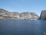
Hetch Hetchy valley is currently partially filled with water. I say partly because there are still hints of what could be there, but much of the splendor is lost.
The Raker Act, passed by Congress in 1913, allowed San Francisco to dam Hetch Hetchy Valley in Yosemite National Park to provide water to the growing city -- but only on the condition that the dam also generate electric power, which is to be sold by the city to its residents at low rates. That provision was intended to prevent Pacific Gas and Electric Co. from establishing a private power monopoly in northern California. Today, PG&E is a private power monopoly in northern California and rather then providing low cost power to the residents of San Francisco, Hetch Hetchy provides power for SF municipal uses (Muni, SFO, City offices) and is sold to Modesto and Turlock Irrigation Districts.
Never before or since has such a desecration of a National Park been allowed. Though Glen Canyon likely would be a National Park today except for the dam.
Most of Yosemite is managed as Wilderness (essentially everything more than 1 mile from a road -- wilderness is best defined by what the Wilderness Act says, not by anything else). It is also where you see fewer people. We have spent several consecutive days on trails in the Yosemite Wilderness, and encountered fewer than 5 people total. You have to walk to see it. Horses are allowed on most of the trails -- like everything this is both good and bad (it defines how trails are constructed, but also means trails can be dusty and worn).
There are many thing to see and not enough time, but a short list of ten places in Yosemite not to miss along with some comments on how to visit.
Part of Yosimte has been protected in some form since 1864, first as a grant to the state of California, then in 1890 as a national park. Visitation grew along with the US population and improvments in access to the park. Today over 4,000,000 people visit the park each year with all the crowding and damage that that implies. (Note: the 2016 report is that it is now 5,000,000.)
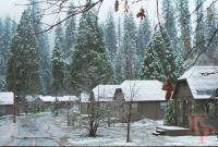
Winter can be very nice or very difficult to visit Yosemite. There are fewer people, fewer campsites available, fewer rooms, and much of the park may be deep in snow (see the Tuolumne page for more on that). This leaves the Valley and Wawona (Wawona accomodations close after the New Year for about 2 months, so just the Valley for most people) (and Badger Pass for skiing). At 4000' the valley floor is usually snow free, and roads are quickly cleared (though the first day can be slushy).
There are a lot of other sources, books, park web sites, etc. that you can use for planning your trip. They spend money to keep them up to date and usually they have the most recent information. So, see the Books and resources page.
Maintained by Keith Price.