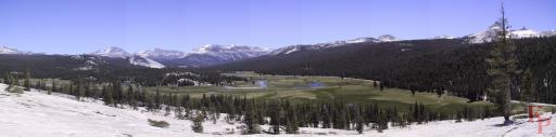
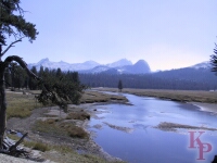
 Tuolumne is the largest alpine meadow in the Sierra, also the most accessible
and most crowded. But compared to Yosemite Valley, or much of Yellowstone,
it is deserted. Even more so in
the winter when it is under several feet of snow. If you get out of your car
and start walking you quickly leave the people behind.
Tuolumne is the largest alpine meadow in the Sierra, also the most accessible
and most crowded. But compared to Yosemite Valley, or much of Yellowstone,
it is deserted. Even more so in
the winter when it is under several feet of snow. If you get out of your car
and start walking you quickly leave the people behind.
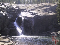
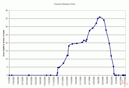 Snow steadily accumulates with each winter storm, then steadily and
quickly melts to feed the streams and falls. The meadow itself provides
San Francisco with subdized water. San Francisco pays nothing to protect
the important watershed. Below the meadow,
Hetch Hetchy has been destroyed by San Francisco
to produce power that is mostly sold to make money for the city. More water
storage is available lower in the Tuolumne basin at Don Pedro.
Snow steadily accumulates with each winter storm, then steadily and
quickly melts to feed the streams and falls. The meadow itself provides
San Francisco with subdized water. San Francisco pays nothing to protect
the important watershed. Below the meadow,
Hetch Hetchy has been destroyed by San Francisco
to produce power that is mostly sold to make money for the city. More water
storage is available lower in the Tuolumne basin at Don Pedro.
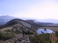
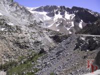
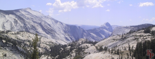 Olmstead Point provides a different view of Half Dome. The higher
Clouds Rest (to the left) provides even better views. This is one of
the critical zones for opening the road each spring -- with the large
expanse of bare rock it is prime avalanches terrain. Walk out to the views
that are a bit beyond the parking lot.
For stereo views,
see
Olmstead Point
Stereo
The smooth granite slabs are ideal for spring avalanches which can delay
plowing operations.
Olmstead Point provides a different view of Half Dome. The higher
Clouds Rest (to the left) provides even better views. This is one of
the critical zones for opening the road each spring -- with the large
expanse of bare rock it is prime avalanches terrain. Walk out to the views
that are a bit beyond the parking lot.
For stereo views,
see
Olmstead Point
Stereo
The smooth granite slabs are ideal for spring avalanches which can delay
plowing operations.
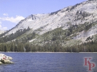 Tenaya Lake, which feeds Tenaya Creek (and eventually Mirror Lake), provides a good break along the road. No motorized boats are allowed in the park so the lake is quiet (except for the road traffic). Strictly speaking Tenaya Lake is not part of Tuolumne, it is in the Merced drainage, but it is on the Tioga Road. |
 Glen Aulin (11 miles round-trip from the road), one of the High Sierra Camps, is along the Tuolumne River and the Pacific Crest Trail. The cascade makes it a beautiful setting. The High Sierra Camps provide one way for people to experience the back country without the effort, but they require luck and advance planning (enter the lottery in the winter). Occasionally, in extreme years the camps do not open due to the late snow melt. From here the trail follows the Tuolumne River through the Grand Canyon of the Tuolumne River (not to be confused with the Grand Canyon) down almost to the Hetch Hetchy Reservoir but skirts well above the lake to the Hetch Hetchy entrance station. |
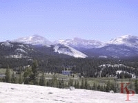
 Along the trails, the peaks surrounding Tuolumne provide outstanding backdrops for the river. From the road, take one of the trails up or down stream. Once you are away from the road the crowds thin out and you can enjoy the scenery away from cars. |
 Pothole Dome with its easy walk up the rock lets you have an overview of the meadow to the east. Pothole is the western limit of the meadow and easily reached from the road. Not too far past here you cross the not very obvious divide between the Tuolumne and the Merced (or locally, the Tenaya). |
 Gaylor Peak stands on the Sierra Crest, on the opposite side of Tioga Pass from Mt. Dana. From here you have views to the east (Mono Lake region) and to the west toward Tuolumne Meadow. |
 Tioga Pass requires a long steep climb from Lee Vinning and Mono Lake. Modern cars have no real problems, but rental campers can be a problem. |
 C
Initially closed due to the Rim Fire in the summer of 2013,
but available again.
Though not really on the Tioga road (parking is off the Tioga road near the
begining -- or in the winter, just before the closure) --
it is on the old road to Big Oak Flat,
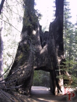
which is now a walking path -- the Tuolumne Grove is a quiet place to
see Sequoias. Including what is left of a Tunnel Tree.
Mariposa Grove on the southern edge of the park
is larger and more accessible (and thus more crowded, but access there
will be restricted for trail reconstruction and rerouting begining in 2015).
C
Initially closed due to the Rim Fire in the summer of 2013,
but available again.
Though not really on the Tioga road (parking is off the Tioga road near the
begining -- or in the winter, just before the closure) --
it is on the old road to Big Oak Flat,
which is now a walking path -- the Tuolumne Grove is a quiet place to
see Sequoias. Including what is left of a Tunnel Tree.
Mariposa Grove on the southern edge of the park
is larger and more accessible (and thus more crowded, but access there
will be restricted for trail reconstruction and rerouting begining in 2015).
 Return to my Yosemite home page.