Most of the park is not Yosemite Valley but most of the people spend
all their time in the valley (in the winter, most of the park outside
the valley is snowed in).
The length of the valley is about the same as the distance across
San Francisco, and is all accessible from one road (the one-way loop road).
Also it is accessible from the shuttles.
(All except the Tunnel/Discovery view and Bridalveil.) The upper (main) valley
shuttle is year round, the lower valley shuttle is summer only, and provides
access to El Capitan and Cathedral Beach.
The best way to see the valley is to first take the shuttle or take one
of the tours, then walk
the trails, then bike the road and bike paths (no bikes off pavement),
then walk some more.
Walk into one of the meadows (on the paved trails or boardwalks)
and just sit or stand and look and listen.
Another location of about the same size that includes
steep glacial walls and waterfalls is
the Lauterbrunnen Valley in Switzerland.
But the falls there are not as high.
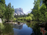 Mirror Lake. is an easy hike up Lower
Tenaya Creek and generally
less crowded than the Vernal Fall view trail from Happy Isles.
Mirror Lake. is an easy hike up Lower
Tenaya Creek and generally
less crowded than the Vernal Fall view trail from Happy Isles.
|
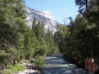 Happy Isles. The Merced begins its trip through the relatively level valley
floor at Happy Isles. This stop on the shuttle
is the access to Vernal and
Nevada Falls via the Mist Trail.
Most people take this trail only to the bridge with the first view of Vernal
Falls. At one time this trail was paved, now it is only mostly paved.
Above the bridge, it is the usual dirt and rocks (especially the rocks on
the Mist Trail section).
Happy Isles. The Merced begins its trip through the relatively level valley
floor at Happy Isles. This stop on the shuttle
is the access to Vernal and
Nevada Falls via the Mist Trail.
Most people take this trail only to the bridge with the first view of Vernal
Falls. At one time this trail was paved, now it is only mostly paved.
Above the bridge, it is the usual dirt and rocks (especially the rocks on
the Mist Trail section).
|
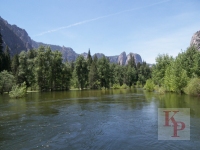
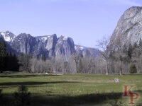 Below the lodge and campground areas you find Cathedral Rocks across from
El Capitan. Bridalveil Creek flows
above and behind this feature before its drop to the valley.
Below the lodge and campground areas you find Cathedral Rocks across from
El Capitan. Bridalveil Creek flows
above and behind this feature before its drop to the valley.
|
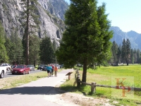
 The large meadow complex near Yosemite Lodge is an outstanding location
to spend time. Trails lead to views of the Merced.
The large meadow complex near Yosemite Lodge is an outstanding location
to spend time. Trails lead to views of the Merced. |
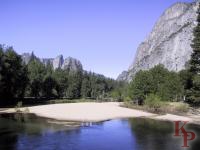
 But with a heavy snowmelt, the river spreads over the usual beaches.
|
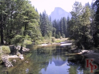 Sentinel Bridge (near the chapel) is a shuttle stop,
a major intersection, and a "classic" view of Half Dome. Afternoon
in low water seems to be best to get the reflection,
though mornings in the spring with high water
are not bad either. Cook's Meadow (behind you while looking at Half Dome)
has trails to explore and provide the best views of
Yosemite Falls.
Current views of Half Dome across a meadow (Ahwahnee Meadow, or close
to the Curry Village bike rental/ice skating shuttle stop)
are available from the
Half Dome Webcam
Sentinel Bridge (near the chapel) is a shuttle stop,
a major intersection, and a "classic" view of Half Dome. Afternoon
in low water seems to be best to get the reflection,
though mornings in the spring with high water
are not bad either. Cook's Meadow (behind you while looking at Half Dome)
has trails to explore and provide the best views of
Yosemite Falls.
Current views of Half Dome across a meadow (Ahwahnee Meadow, or close
to the Curry Village bike rental/ice skating shuttle stop)
are available from the
Half Dome Webcam
|
|
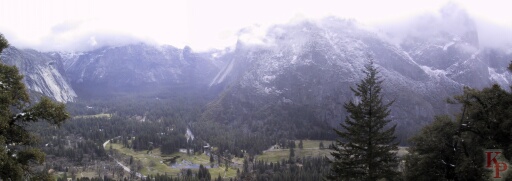
Snow is always possible into the early spring. But if you get up (and from the
floor of a glacial valley, up is the important word) the trail
(Yosemite Falls Trail) you get good views of the valley floor.
|
 |
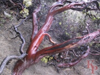 The distinctive manzanita is common on the lower slopes. This one is on
the Yosemite Falls trail, not the Yosemite Falls path where most people
go, but the trail that eventually gets to the top of the Falls.
The distinctive manzanita is common on the lower slopes. This one is on
the Yosemite Falls trail, not the Yosemite Falls path where most people
go, but the trail that eventually gets to the top of the Falls.
|
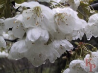 The dogwood blooms in the spring. There are some around Sentinel Bridge,
and a large number below Bridalveil Meadow. And some are scattered among
the lodge and residential cabins (including one pink dogwood).
The dogwood blooms in the spring. There are some around Sentinel Bridge,
and a large number below Bridalveil Meadow. And some are scattered among
the lodge and residential cabins (including one pink dogwood).
|
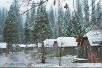 Winter sometimes brings snow to the valley floor. The 4000' elevation
is low enough that it will not last long so enjoy it while you can.
Winter sometimes brings snow to the valley floor. The 4000' elevation
is low enough that it will not last long so enjoy it while you can.
|
 Weekend traffic with early high-waterfall flows can be difficult. It is
faster to walk at times. The Loop to Curry and the stop at Sentinel Bridge
can be especially difficult. At peak times, cars are held at the Badger
Pass ski are parking and released to Glacier Point
only after cars have
exited. If you are staying overnight near the park, take YARTS!
Look at the Yosemite NPS
Traffic Forecast Page.
Weekend traffic with early high-waterfall flows can be difficult. It is
faster to walk at times. The Loop to Curry and the stop at Sentinel Bridge
can be especially difficult. At peak times, cars are held at the Badger
Pass ski are parking and released to Glacier Point
only after cars have
exited. If you are staying overnight near the park, take YARTS!
Look at the Yosemite NPS
Traffic Forecast Page.
|
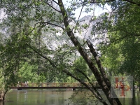
 The foot (and often bike) trails lead to crossings of the Merced
(with April snow)
The foot (and often bike) trails lead to crossings of the Merced
(with April snow)
|
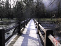
 Crossings in high snow melt times are often also interesting. Note how close
the water is to the bridge deck. (At flood stage, it reaches the deck.)
Crossings in high snow melt times are often also interesting. Note how close
the water is to the bridge deck. (At flood stage, it reaches the deck.)
|
 Return to my Yosemite home page.